
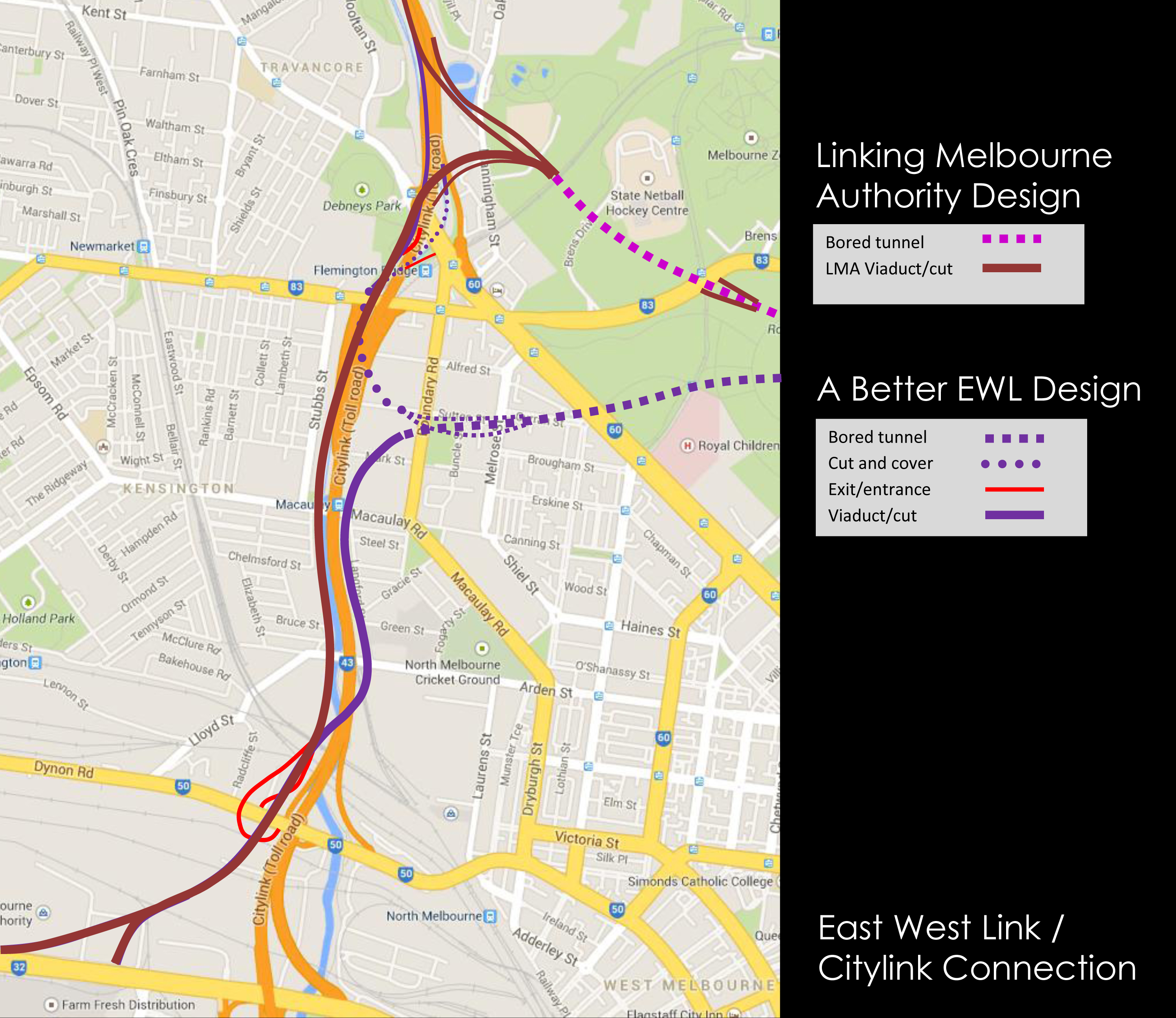
As previously reported (East West Tollway to trash an inner-city oasis and an update on the East West Link), many people in Melbourne are dismayed over the destruction that the controversial East West Link will reap over the inner city communities and significant parklands of Melbourne. At its essence Melbourne has become very much a design city and it is therefore not surprising that such a bad design has been widely criticised and that better alternatives have arisen.
At the time of writing the Assessment Committee is part way through its 30 day hearing schedule. Lawyers and experts from all sides have been slugging it out debating Melbourne’s future, whilst the only update to the public seems to be an excellent community blog written by volunteers. This is a process that will hopefully lead to a revised design which will be better outcome for the community at large. But how did it get to this stage? Where was the community consultation? How did the LMA reference design change based on this consultation?
The East West Tunnel project will have a near permanent presence on the environment, our communities our heritage and our finances. This of all projects must therefore engage the public to produce an outcome that is better across the board.
With this situation as the backdrop, Atelier Red + Black have undertaken a pro-bono project with a group of local professionals under the banner of Better East West link Design. The objective was to develop a road design from the community group, Safety Net for Royal Park, to create a better overall design for Melbourne. The central premise of the design is that the underutilized Arden Macaulay precinct is a far better location for the City Link connection than Royal Park.
Using the City of Melbourne’s vision for Arden-Macaulay as a guide, Atelier Red+Black set about creating a vision to integrate the Better East West Link Design into an under-utilized commercial fringe of North Melbourne. Located beside the Citylink Freeway and Moonee Ponds creek, the proposed site spans from Alfred Street to Macaulay road with Boundary Rd as its eastern perimeter.
The design integrates the proposed viaduct/tunnel for the link while also retaining nearby heritage buildings. It also effectively utilizes alternate programs such as a mid-sized Retail strip and a large retail outlet to act as visual & acoustic sound buffers. The design also embraces the saw-toothed grain of the existing warehouses into various aspects of the new design, thus referencing the history of the area.
Other programs within the project boundary include:
- Large Commercial precinct along Citylink Freeway and Alfred Street – a buffer program located close to the freeway which also benefits from its proximity to Flemington Road and the tram network.
- Smaller Commercial precinct along Boundary Road
- Public Gardens proposed at Alfred St.
- Neighborhood Park and playgrounds at Sutton Street (beside the new Civic hub).
- Smaller Residential Precinct along Boundary road – which benefit from proximity to the city and nearby parks. They also provide a built form transition towards the taller building envelopes closer to the freeway.
- Medium-Density Residential Precinct along Macaulay Road – located to symbiotically function with the mid-sized retail strip & promenade.
- Secondary school and Neighborhood sports centre – to demonstrate that their programmatic requirements can be met within inner-city locations. The school also acts as a landmark visual terminus to the corner of Boundary Rd, Macaulay Rd and Canning St.
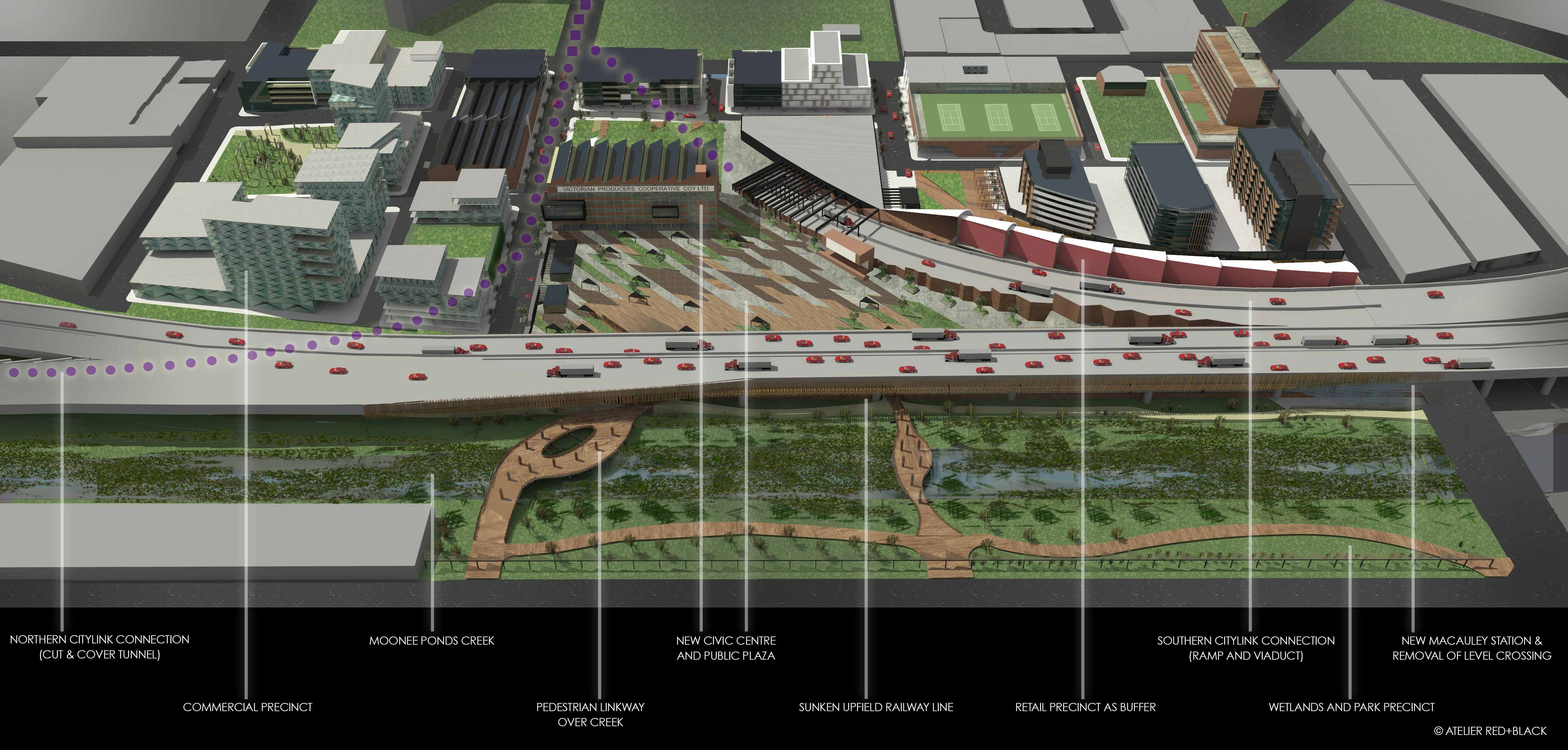
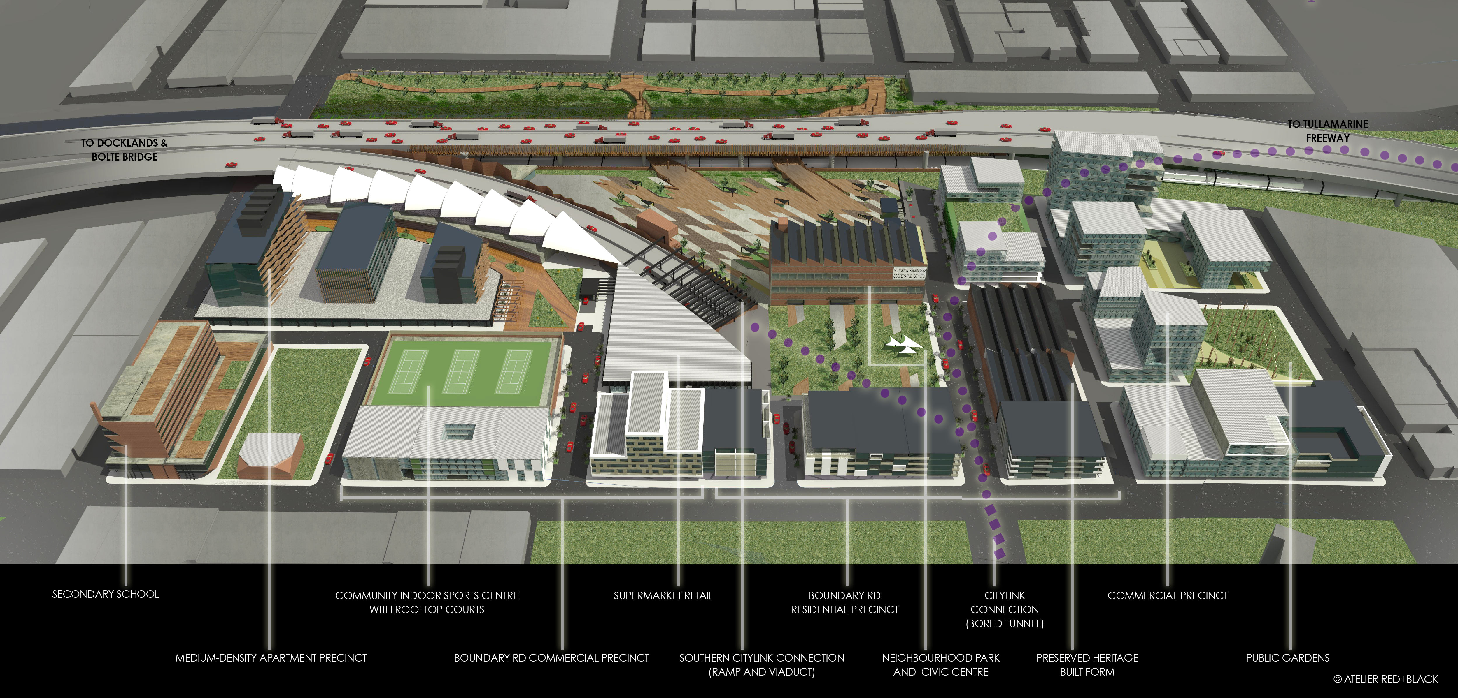
At the heart of the proposal is a generous creation of a public Plaza, new Civic Hub and Parklands. Instead of the isolation of Moonee Ponds creek, the design aims to integrate it into the urban fabric of North Melbourne and Kensington by improving pedestrian links across to new public spaces on both sides. One of the parallel outcomes of doing so is the removal of the level-crossing at Macaulay Road and the sinking of the railway line (with a new Station design) to improve the connection between the suburbs of Kensington & North Melbourne.


Victorians get only one opportunity to design and construct this project. If we build it and it fails for any reason we have blown over $8 Billion in the process. The stakes have never been higher for Melbourne.
To review the design options and for further information check out the website
Architecture is for Everyone.


Great initiative, Michael. The betterEWLdesign website is very well resolved, clearly you have dedicated significant time and energy to this project. I also appreciate your attitude that instead of denying the project, active and committed involvement may provide the opportunity for change.
Your comment at the end of the Channel 9 slot was compelling: we can do it right or very badly wrong.
Do you have avenues for further engagement at a political level?
Thanks for your comments Warwick. The next step in the process is to present this proposal to the Assessment Committee this Thursday. Where it will end up is very much unknown. What is obvious though is that if we leave the deign of our built environment to traffic engineers we will have our parks and suburbs turned into flyovers and on ramps.
Good work, let everyone know how you go.
Pingback: State Government Reveals Final East West Link Design | The Red and Black Architect
Pingback: 2014 Retrospective | The Red and Black Architect
Pingback: The Red + Black Architect – Post 100 | The Red and Black Architect
Pingback: Ted Baillieu, The Architect Premier – Part 3 | The Red and Black Architect