
In a 8-page, plastic-wrapped newsletter released late last week, the Linking Melbourne Authority announced amongst spin and puff that the development plans required as the final step of the planning permit had been endorsed by the Planning Minister. On any other planning permit these development plans, or ‘endorsed drawings’ as they are also known, will detail all the design modifications from the permit conditions and essentially finalize the design which has been approved. Whilst they will not detail the construction engineering aspects they typically cover such things as final finishes, proposed overall dimensions and all the features and aspects of the design proposal related to planning. In any other project, be it a 100 storey tower or a minor residential extension, these plans are public documents. However such is the secrecy around the East West Link that, like the ‘business case’, these documents are under lock and key away from public scrutiny.

As a consequence of this veil of secrecy very simple questions pertaining to what has been approved cannot be answered. In Parkville, seven tollway flyovers cut through a residential precinct. The animation gives perhaps the best indication of what residents should prepare themselves for. It is very difficult to determine if sound and privacy barriers will be installed, what height and form they will take and how effective they will be. Other basic questions include how tall are these flyovers? How far away are they exactly? How will the road be lit at night?
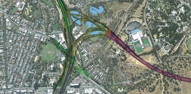
This LMA map is currently the most detailed plan available to the general public.
This situation leads to only two possible conclusions. The first possibility is that these issues have been resolved in the development plans, as they should have. These details are then being deliberately withheld from public scrutiny, for the benefit of the Liberal Party election prospects and public relations. The second possibility is that these details have not been finalised and are therefore not part of the development plans which were endorsed by the Planning Minister. This would be an absolute disaster as the controls for what constitutes an acceptable design response would be transferred to either the LMA or the construction consortium who would be entitled to build whatever was expedient and cheap for them to construct.
Secret Property Reports
The Victorian Government’s dungeon of secret documents has also been expanded to include the Property Impact Reports which were required as a condition of the planning permit. These reports supposedly document local properties which will be impacted and were used to determine which properties would be offered voluntary acquisition. Was it comprehensive? Which properties were reported upon? What did it take into consideration? Only very few guards within the secret dungeon have access to this document, so it is impossible to say. Despite this, from media reports it is possible to draw a rough map of which properties have and have not been offered acquisition. Whilst any number of government ministers can trot out the catch phrase ‘the line had to be drawn somewhere’ it is clear from this rough map that the line that was actually drawn does not treat properties fairly based on distance. The line that separates between an optional exit and 5+ years of misery prioritises houses over others and does not use logical features such as existing laneways to determine its location.

Purpose of mystery buildings confirmed.
In a previous post discussing the then newly released final design, two newly proposed ‘mystery’ buildings in Parkville were highlighted by a freeze frame shot on the official video. At the time with no announcement or description of what they were, we were left to guess the purpose. After a subsequent twitter exchange and a discussion with the Linking Melbourne Authority, it has been confirmed that these two buildings will be the new 24 hour Freeway Control Centre and the Operations and Maintenance Management Facilities. These buildings should have been included within the Comprehensive Impact Statement and public hearings process but were omitted. In order to make this location work for the emergency operations vehicles an additional ground level road through Royal Park will also be required. The alternative fastest route into the tunnel is a 3.5KM trip via Brunswick road.

Planning details such as the number of car parks for these facilities, shadowing impacts, building form, window location and overall dimensions are all either secret or as yet un-designed. The design should have been finalised in order to have been included on the development plans for endorsement.
West Parkville to be cut off.
Another detail which has snuck through broader analysis is the road connection between West Parkville and the Western and Southern Suburbs. In order to facilitate large traffic volumes exiting City link from the north, the only connection via Lennon Street will be entirely cut off. This will add over 2.5 Kilometres to any trip going West via racecourse road or South via boundary road or City link. Linking Melbourne Authority is aware of this problem and have verbally agreed to investigate possible solutions.

Road network relying upon Lennon Street to Boundary road connection

The diagram above presumes that drivers will only U turn where they are legally allowed to do so.
Real life ‘Utopia’ spin
In a case of life mimicking art it seems that the PR department at the LMA has taken a leaf out of the fictional ‘Nation Building Authority’ depicted by the ABC comedy / documentary Utopia. In order to sell the extension of the wetlands (at the expense of Royal Park’s Ross Straw Field) the glossy brochure announced the following:
“The wetlands will be accessible by a series of high quality boardwalks and complemented by a significant water themed playground, a new education and interpretative centre, and community facilities including barbecues, seating and shelters.”
Linking Melbourne Authority, Western Gateway Brochure (page 2)
This description was accompanied by an artist impression indicating a vague building within a park setting.

Artist Impression
Naturally the education and interpretive centre was not included in the consultation process, Comprehensive Impact Statement or in the public hearings. It was therefore a big surprise that it was included as part of the ‘final design’. There has been no discussion about how this centre would operate, if there would be buses dropping off school groups or the design location or footprint of any of these buildings. Furthermore it is not entirely clear if the Linking Melbourne Authority even has a planning permit to construct these buildings as they are not ‘normal’ to the purpose of providing a transport link. In response to being pushed on these questions, the LMA reportedly told the City of Melbourne (on October 7) that the Education Centre would not be a staffed centre but a series of interpretive signs around the wetlands. Perhaps the LMA should tell that to their media spin unit.
The issues highlighted here are a summary of some of the known unknowns. The Liberal Government would have you believe that this project is ready to start in a few weeks yet the public has very little idea of what has even been approved. With such a secretive process the question is: what else is being kept in the secret dungeon of documents with the business case, property reports, signed construction contract and the development plans?
The public deserves to know. Architecture is for Everyone.


A few late additional pieces of information have also come to light.
1. At least 1 house depicted in yellow on the acquisition map has been offered voluntary acquisition.
2. Manningham street will need to be closed during the construction period, so that it can be lowered to pass under the new flyovers.
Thanks to those sharing information!
Pingback: East West Link and the Secret Development Plans Posted | MCAT
Pingback: East West Link Secret Documents Revealed | The Red and Black Architect
Pingback: The Red + Black Architect – Post 100 | The Red and Black Architect